 An official website of the United States government.
.")
There are a few things you will need to do as you prepare to take your students on an MDMAP survey. Some things will only need to occur before your first survey, while others should be done before every survey.
Before First Survey | Before Every Survey |
|---|---|
|
|
Selecting a Site
Your class will either be surveying a site that has been surveyed previously, or starting a new site. Existing sites can be found on https://mdmap.orr.noaa.gov/. If a site has already been surveyed, you can compare your data to previous surveys, skip some of the initial steps (such as the Shoreline Site Characterization Form), and focus more effort on collecting and analyzing data. If there's a site near you that hasn’t been surveyed in a while, contact the NOAA Marine Debris Program staff at md.monitoring@noaa.gov to confirm that it’s an appropriate site. You’ll then use the information that has already been entered to find and continue surveys at that site.
Is There An Existing Survey Site Near You? Check the MDMAP Database!
| Teacher Tip: If a site near you is active and surveys are conducted by an organization, contact them to collaborate! Invite them to speak with your class prior to your official survey. |
The location you choose can become an opportunity for students to build place-based knowledge and connection to your site. Students can discuss or research physical characteristics of the area, such as currents, wind, or geology; biological characteristics, including local species; or community characteristics, such as relevant work of local organizations and indigenous land stewardship.
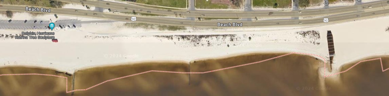
As you compare potential sites for your survey, it may be helpful to look through maps of nearby areas. Exploring satellite imagery can help you identify human use patterns, potential obstacles, and areas of interest.
| Cross-Curricular Concept: Incorporating maps into your decision-making process can help students practice reading coordinates, understanding maps and legends, and exercising digital thinking skills in a targeted environment. |
Discussion Starters - Selecting Your Site
Selecting a site with intentional, place-based goals and discussion in mind can increase the effectiveness of and commitment to the survey among your students. Some ways to secure student buy-in include the following discussions:
- What questions do you and your students have about marine debris in your community?
- Do you want to compare debris accumulated in different areas?
- Do you want to look at human impacts, perhaps near a public park, river or stream, or urbanized area?
- Are there beaches and shorelines that are meaningful to your students or to the larger community?
- What marine debris concerns have they noticed in the community?
| Teacher Tip: Questions can be compiled in a driving question board posted in your learning environment and added to throughout the process. Encourage democratization of the process through research, proposals, and voting. |
| Teacher Tip: Committees or groups are another way to increase student ownership and engagement. Student groups can be responsible for supplies, site selection, transportation, safety, etc. This will balance the workload between students and educators, provide students with opportunities to practice leadership and responsibility, and encourage buy-in across the classroom. Ideally, students will be returning to the site regularly, increasing their level of investment and commitment to the effort over time. |
To learn more about selecting an MDMAP site and see some visual examples, check out MDMAP Training Video 2: Choosing a Site. Discussion questions for all of the MDMAP Training Videos are also available.
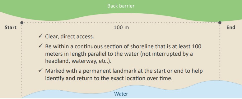
If you decide to survey a new site, rather than using an existing site, it is as simple as identifying where you want to survey and collecting the site’s corresponding information on the Shoreline Site Characterization Form. This information will help you and future surveyors ensure that you’re monitoring the same spot, and it will document basic information about the site that could influence the amount of debris found. This form only needs to be completed once when the site is established. New sites should meet the following characteristics:
While selecting your site, consider whether you will be conducting a survey only one time or if you will be returning multiple times. Technically, monitoring is defined as a consistent, repeated measurement taken over time. Part of NOAA’s goal for MDMAP is to engage volunteer monitors monthly. However, this may not be possible for your learning environment, and that is okay!
Standardized data collection at the same location over time can be used to help answer questions about marine debris, such as how widespread the problem is, how it’s changing over time, and what kinds of debris are most common in your area. One-time or relatively infrequent data collection following the survey protocols can still be contributed to the database and support your community and NOAA’s understanding of debris issues.
Your student group may only be able to conduct one survey, or perhaps you will engage quarterly or even monthly! The frequency of surveys you are able to conduct may impact the kind of site you are interested in surveying. You may also want to coordinate directly with a community group who is conducting regular surveys, who can not only support a more robust set of data for your students to analyze, but can also share their knowledge and expertise on the issue through field trips, presentations, or projects.
Planning to Dispose of Collected Debris
When planning your survey and determining your site, you may want to research how you are going to dispose of debris you collect during your survey. This will differ from place to place, particularly in remote areas that may have limited access to alternative disposal methods like recycling, composting, or municipal trash pickups. These considerations can be a part of overall planning, and you can work with students to discuss waste management cycles in your community and understand where the trash you collect will end up. Here are some suggestions for effectively sorting and disposing of the debris you collect:
- Create a flowchart to demonstrate the flow of debris through the waste stream, incorporating research into waste management practices in your specific community context.
- Plan to sort your debris on the beach. Some possible groupings include trash, recyclable, and reusable items. (These groupings will be different from the standardized categories in your MDMAP survey.) Be sure to research local recycling options and ensure your materials can be recycled effectively (i.e., they are clean, dry, and the appropriate material types). You may want to print and laminate signs for each of your sorting groups.
- If there are trash cans nearby, assess whether these would be a good choice for disposal. If, for instance, they are uncovered or overflowing, most of the debris you collected will end up right back on the beach!
- If you need to bring your debris to another location (e.g., your school or local transfer station), pack enough bags or other receptacles to transport it.
- With adequate advanced coordination, you may be able to connect with local cleanup groups or other community organizations who can provide support or even a dumpster nearby for disposing of debris.
- Assessment of the debris you are disposing of, including documentation of its weight, can help build students’ data literacy! See the “Using the Data” section in After the Survey: Entering Data and Reflecting on the Experience for additional data analysis suggestions in the classroom.
| Cross-Curricular Concept: Mismanaged waste is one of the top ways that debris escapes into the environment. You can discuss this with your students by reviewing Reckoning with the U.S. Role in Global Ocean Plastic Waste, a report by the National Academies of Science, Engineering, and Medicine with funding from the NOAA Marine Debris Program. This report includes a number of thought-provoking takeaways, including an analysis of plastic waste and its management in the U.S. |
Practice, Practice, Practice!
A great way to ensure success on the day of your survey is to practice ahead of time. Practicing can help your students feel more confident in the process, avoid incompatible data collection, and provide a reference for the amount of time and attention the survey will take. There are a few different ways to approach practice depending on the space you have available for your students. Please note that practice data should not be entered into the MDMAP database. Only data collected from shoreline surveys are applicable for the database.
To see an example and learn more about what your survey will look like, check out MDMAP Training Video 3: Conducting a Survey. Discussion questions for all of the MDMAP training videos are also available.
| Teacher Tip: When practicing and when conducting the surveys, remind students all survey measurements are in metric, not imperial units. |
Practicing on Your School Campus or Other Outdoor Area
- Identify an area that you would like to survey and clean up. You can try and measure a comparable, 100-meter stretch, scale down to a smaller area, or simply skip the measurement steps and focus on identifying and collecting debris. Use the same tools that you are planning to use for your official shoreline survey to mark your area and transects. Provide students with the opportunity to try out any GPS apps or equipment for recording your location and measuring your transects.
- If you will be surveying a new site: Provide students with a Shoreline Site Characterization Form. While only one form needs to be created for your official survey, having each student practice will help strengthen data recording skills, attention to detail, and understanding of the process. Guide students through each field on the form.
- Once you have your site location noted and your transects marked, assign student pairs to walk each transect and identify the debris they find. Provide feedback on their strategy as appropriate, ensuring that they are maintaining an even transect and accurately recording and collecting debris. This might be tricky, so it may be helpful to provide specific instructions, examples, or non-examples to help students understand how and why to walk the perimeter of the transect. These examples could also be shared in the classroom before heading outdoors.
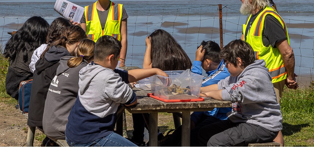
- As you survey the debris, refer to the Marine Debris Item Categorization Guide to help clarify debris items and types. You may want to preview MDMAP Training Video 4: Categorizing Debris before heading out.
- Following your practice session, appropriately dispose of any collected debris.
- While practice data should not be entered into the MDMAP database, don’t let it go to waste! You can use practice data to strengthen students’ graphing and analysis skills, or to create infographics or other presentations to raise awareness about debris issues in your campus or community. See the “Using the Data” section in After the Survey: Entering Data and Reflecting on the Experience for example activities.
Practicing in the Classroom
If you don’t have access to a safe outdoor space for a practice cleanup or you encounter challenges in a planned practice cleanup, you can also set up a practice in your classroom! There are a few ways you can do this:
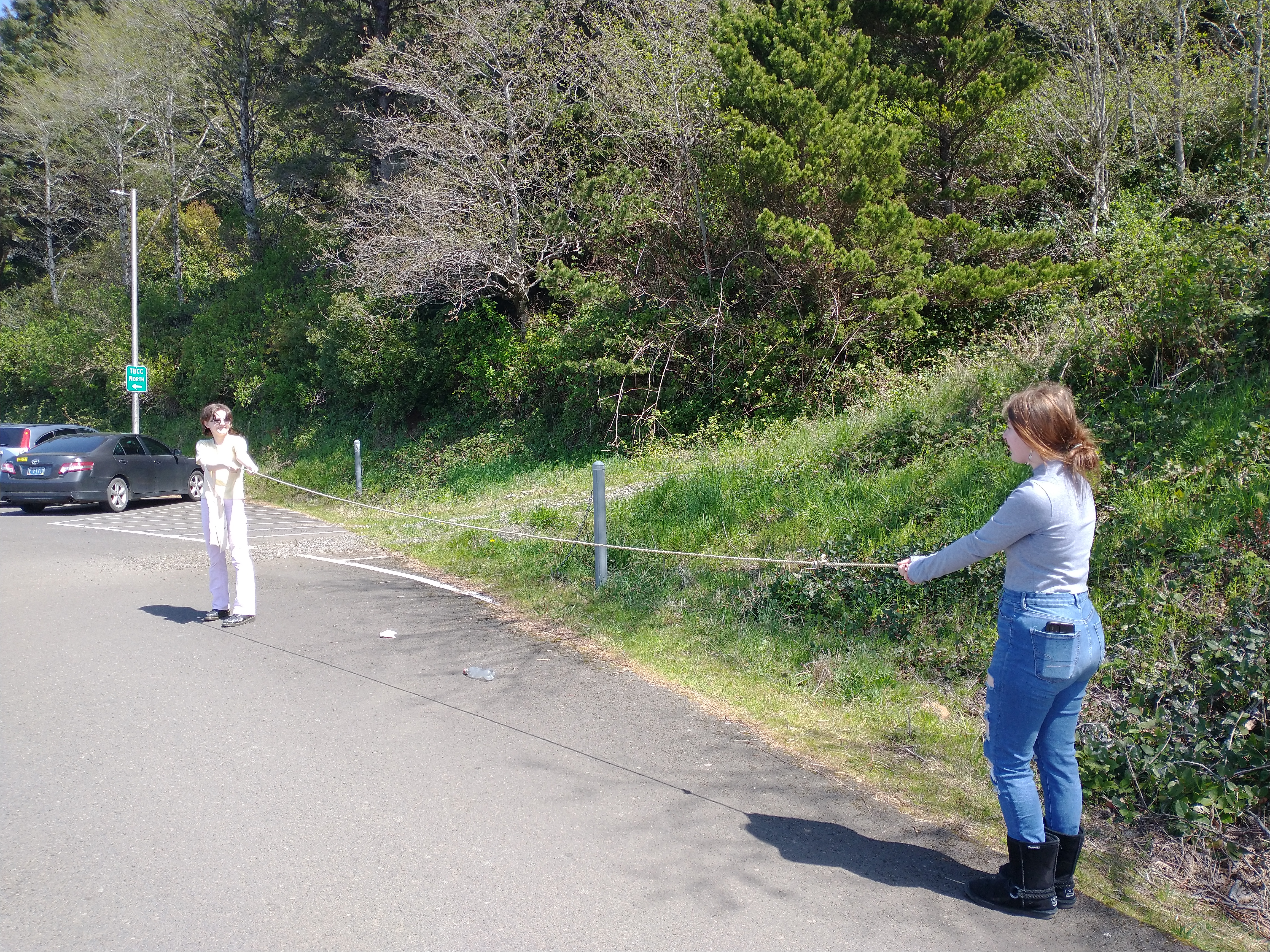
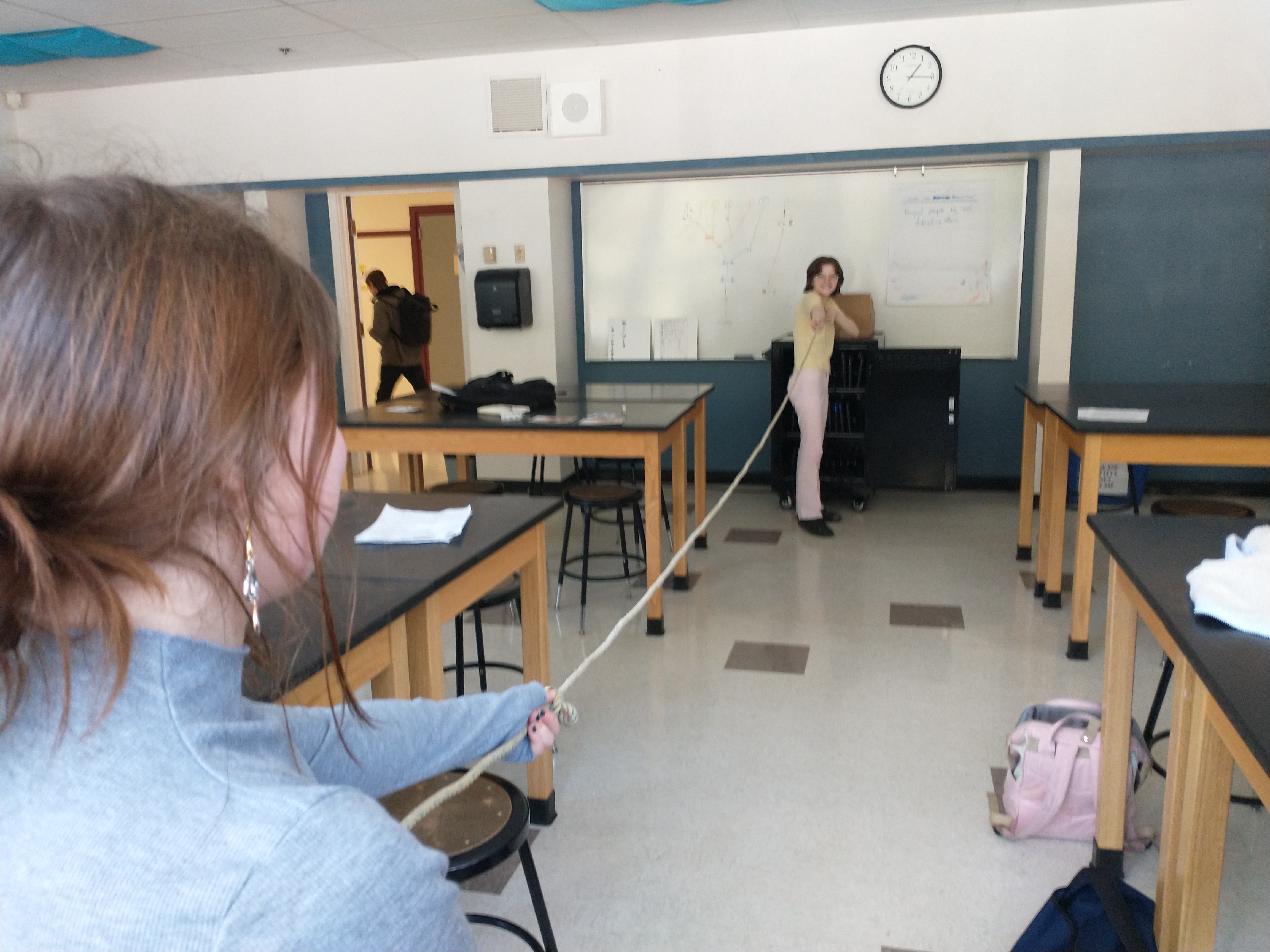
- Use “Science Theater” to demonstrate walking a transect. Student pairs can hold a 5-meter rope taut between them to practice maintaining a 5-meter-wide transect and model collecting debris. Students can act out what to do, what not to do, and creative interpretations of the protocols, while soliciting feedback or questions from the student audience.
- You can also create a “shoreline” in your classroom with colored fabric, paper, tape, or other markers for water, the beach area, and the back barrier. You can incorporate clean debris items collected from past cleanups or even the class waste bin. In this model, you can demonstrate all elements of the survey protocols, including collecting data within a transect area. If available, it may be helpful to record the directions on the board or on large chart paper for easy reference.
- After watching the tutorial videos, students can try writing their own protocol procedures and test them in the classroom or on campus. This is a great way to help students better understand and make sense of the protocol directions, but be sure the procedures for your official survey match up with the standardized data collection protocols. If you are not sure that your student-generated directions are sufficiently similar, you can reach out to md.monitoring@noaa.gov.
- You should also practice using the Marine Debris Item Categorization Guide. You can use example debris from previous cleanup efforts, clean classroom trash, or sample images of tricky items to identify.
Discussion Starters - After Your Practice Survey
Reflect on the survey experience:
- What surprised you?
- What was the most challenging part?
- What can we change or improve upon when we conduct our official survey?
Discuss differences between the practice site and your official survey:
- Are there additional safety considerations you should be mindful of?
- Will the debris you collect be different? Why or why not?
Discuss the scientific process for surveys:
- Why do we use these random transects to conduct the survey?
- Why should we aim to return to the same survey site over time?
- Why is it important that we all use the same methods?
Discuss the plan for your official survey:
- What questions do we have about the debris in this area?
- What are our goals for the survey? What do we want to achieve?
What to Bring
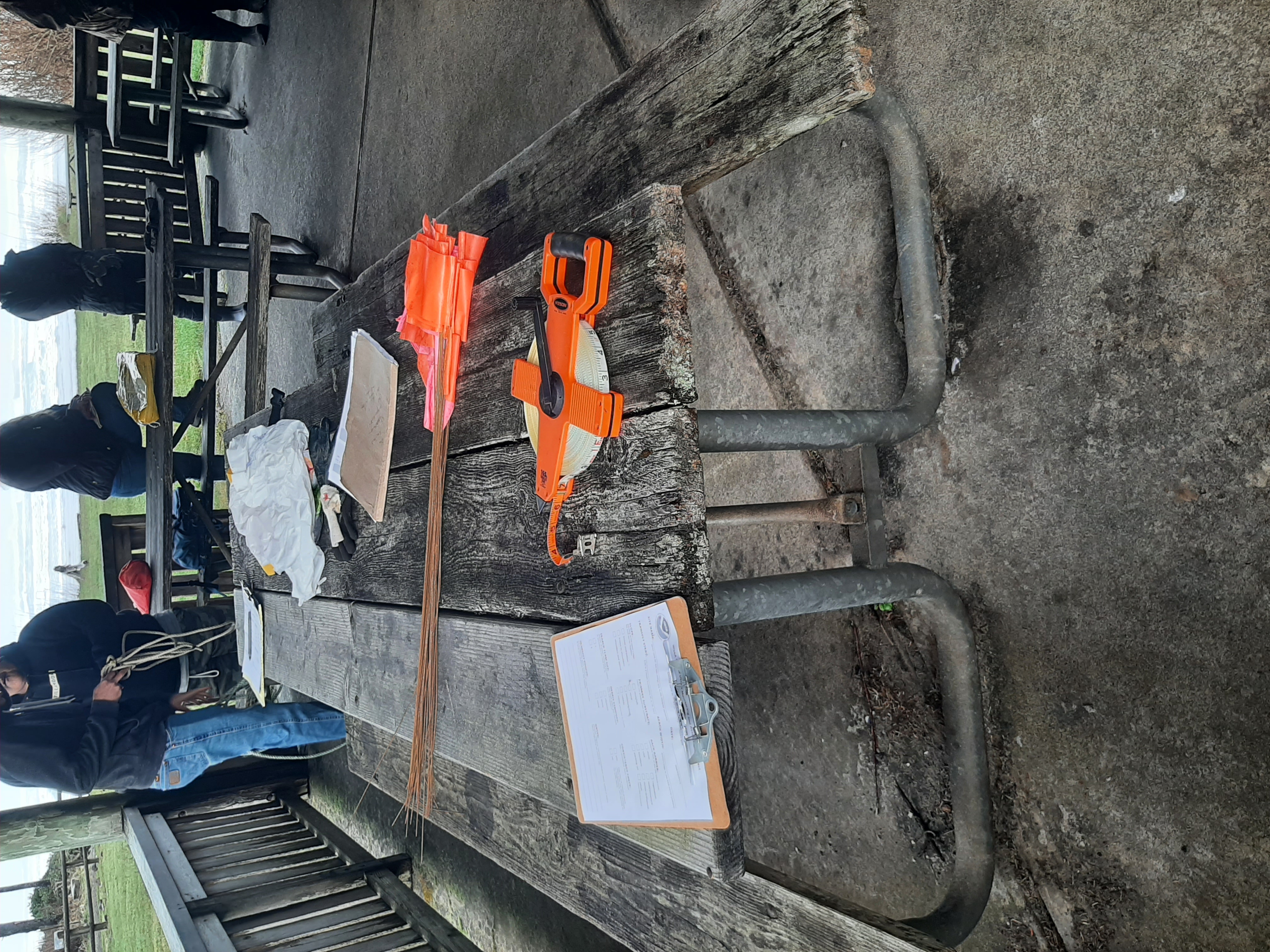
Having the right supplies is crucial for a successful survey. Below we’ve compiled a list of the necessary materials for conducting an MDMAP survey and their use in the survey, with some options on how to gather each one if you aren’t sure where to start.